


6 DAYS TO GO
Kakamega is a town in western Kenya located around 30 kilometers north of the Equator. It serves as the county seat of Kakamega County, which has a population of 1,867,579 people (2019 census). Kakamega is 52 kilometers north of Kisumu, Kenya's tenth largest city and the centre of Luhya-land. Kakamega has an average elevation of 1,535 meters.
After Nairobi, Kakamega is Kenya's second most populous county. Butere, Mumias East, Matungu, Khwisero, Shinyalu, Lurambi, ikolomani, Lugari, and Malava are the county's nine constituencies. Kakamega got its name from the luhya word "kakamega," which meant "pinch" and was used to describe how European colonists ate the main dish, ugali.
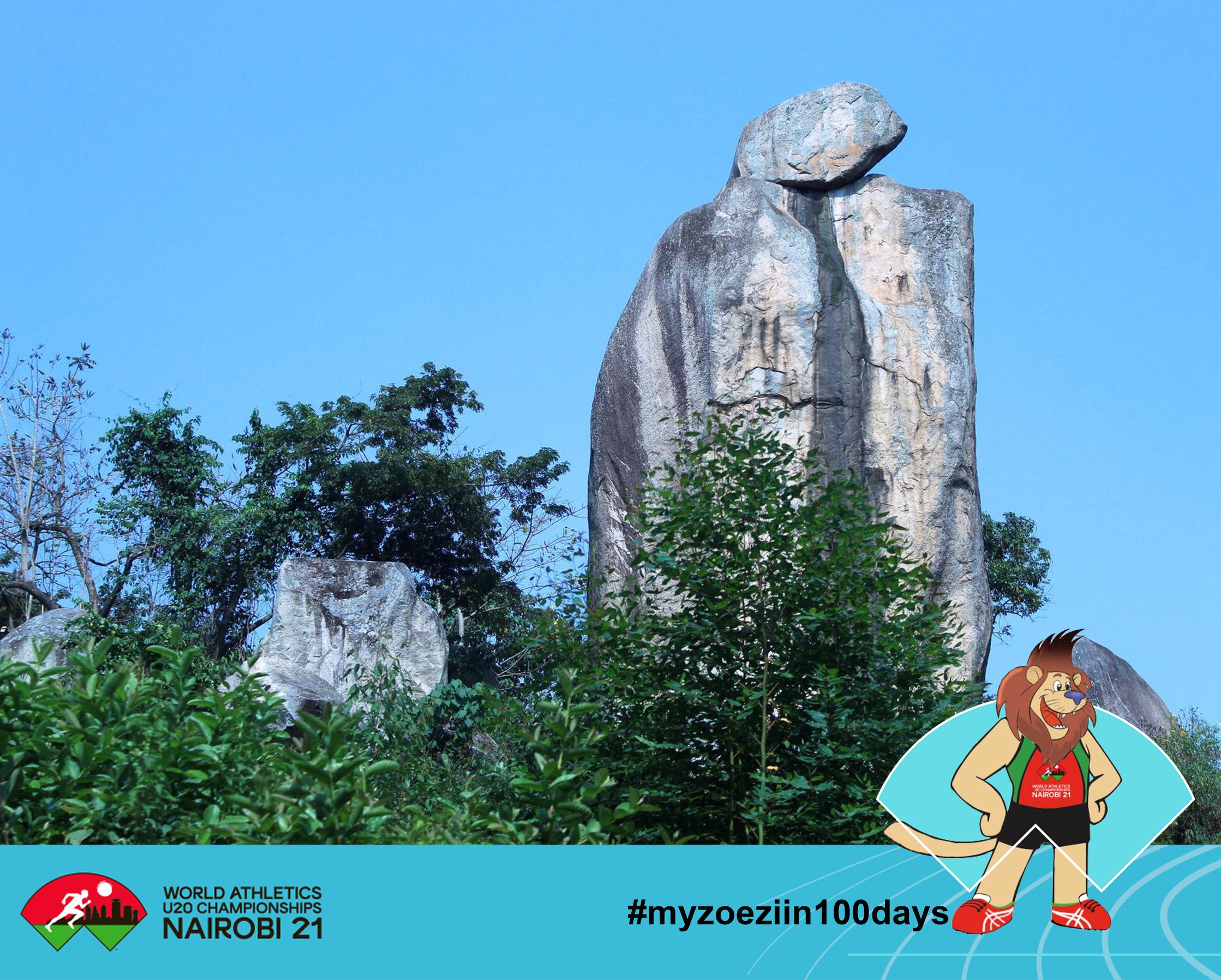
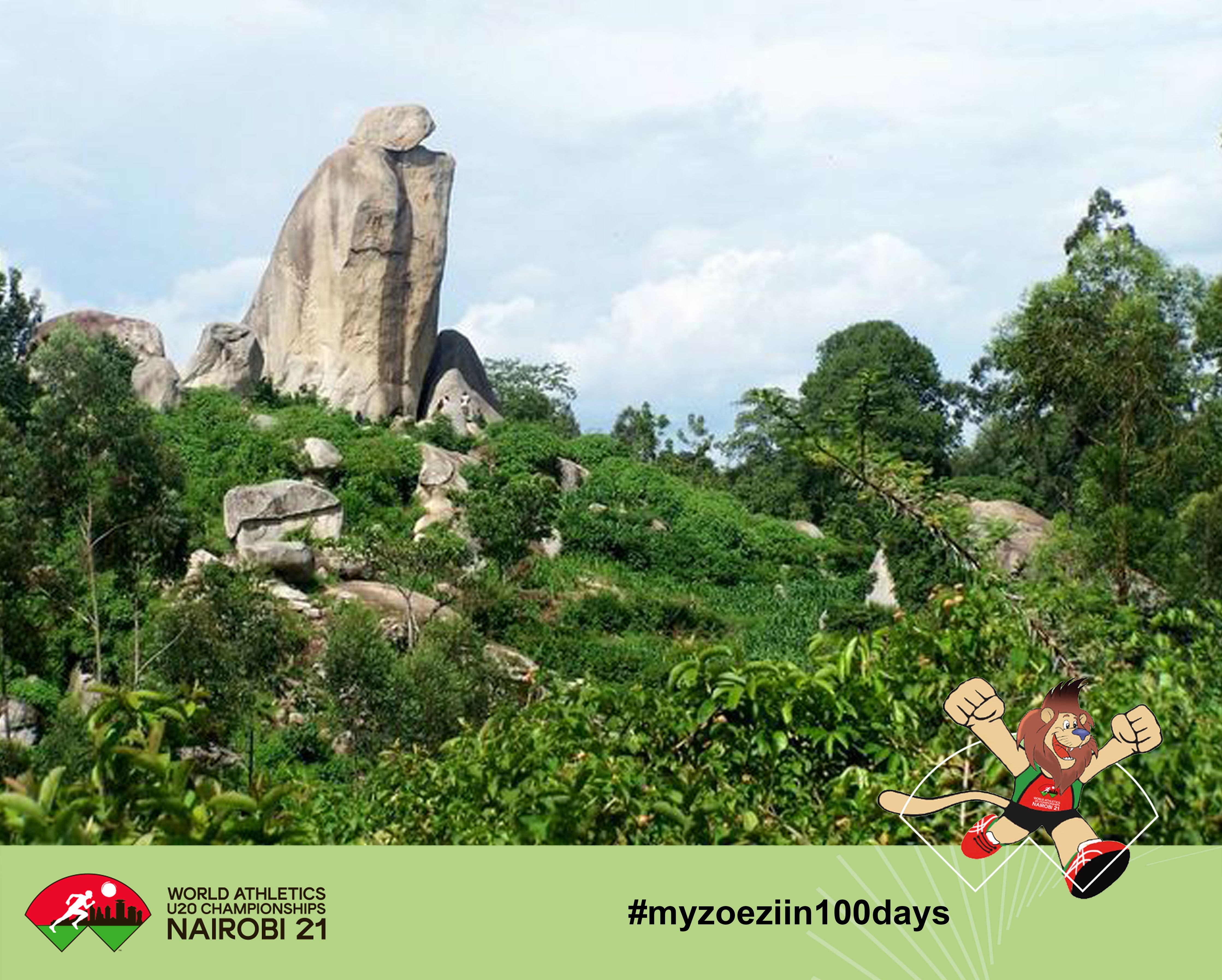
The biggest tourist attraction in the area is the Kakamega Forest. The Crying Stone of Ilesi (Ikhongo Murwi), which is located along the Kisumu-Kakamega route, was formerly another popular sight. It's a 40-meter-high granite dome that resembles a human figure with water-dropping "eyes."
This rock is said to represent an image of a jilted woman grieving because she was pushed out of her matrimonial house and denied access to her children, according to local legend. According to legend, the Isukha clan had conflicts with Nandi warriors in the past, and they were usually defeated. The Nandis believed Isukhas had beaten them because of the rock's superpowers.
The Nandis attempted to bring the rock down but were unsuccessful, losing almost 100 of their warriors in the process. The tourist attraction location is currently obscured from view from the road by planted eucalyptus trees, which have depleted the rock's water supply and caused the "Crying Stone" to dry up. This effect is linked to the global climate change that we are witnessing.
It's a formation made up of a big boulder resting on a rock column with water running from a groove in the centre, according to scientists. It is, in fact, an acid plutonic rock made up primarily of quartz, alkali, feldspar, and mica, according to scientists.
The stone, on the other hand, is prized and holds enormous cultural and spiritual significance for the Luhya group, particularly the Isukha sub-tribe.
The Isukha dwell in the vicinity of the rock formation. "To visitors, it's just another attraction," explains 78-year-old John Shikhomoli, "but to us residents, it influences our lives in many ways, just as it did our forefathers'."
The community has fought the government's or private developers' attempts to take over the wailing stone and turn it into a resort. When the stone cries, villagers believe it is a good omen, indicating a bountiful harvest, for example. When the neighborhood is experiencing a drought, rituals are performed here to encourage the gods to send rain.
Other rites are done in the event of a disaster. According to Shikhomoli, the site is also utilized to cleanse incest victims in families. Cleaning rituals "Those implicated in acts of incest are cleaned before they can be re-accepted into the community," explains Shikhomoli of the Shimichiro cave beneath the wailing stone.
Those who have been affected are taken to the cave and given traditional herbs as part of the cleansing procedure. According to witnesses, the cleansing is so powerful that no misfortune follows those who have been cleansed. Several animals are sacrificed at the foot of the weeping stone during night-long festivities to placate the gods for rain or to escape impending calamities such as famine.
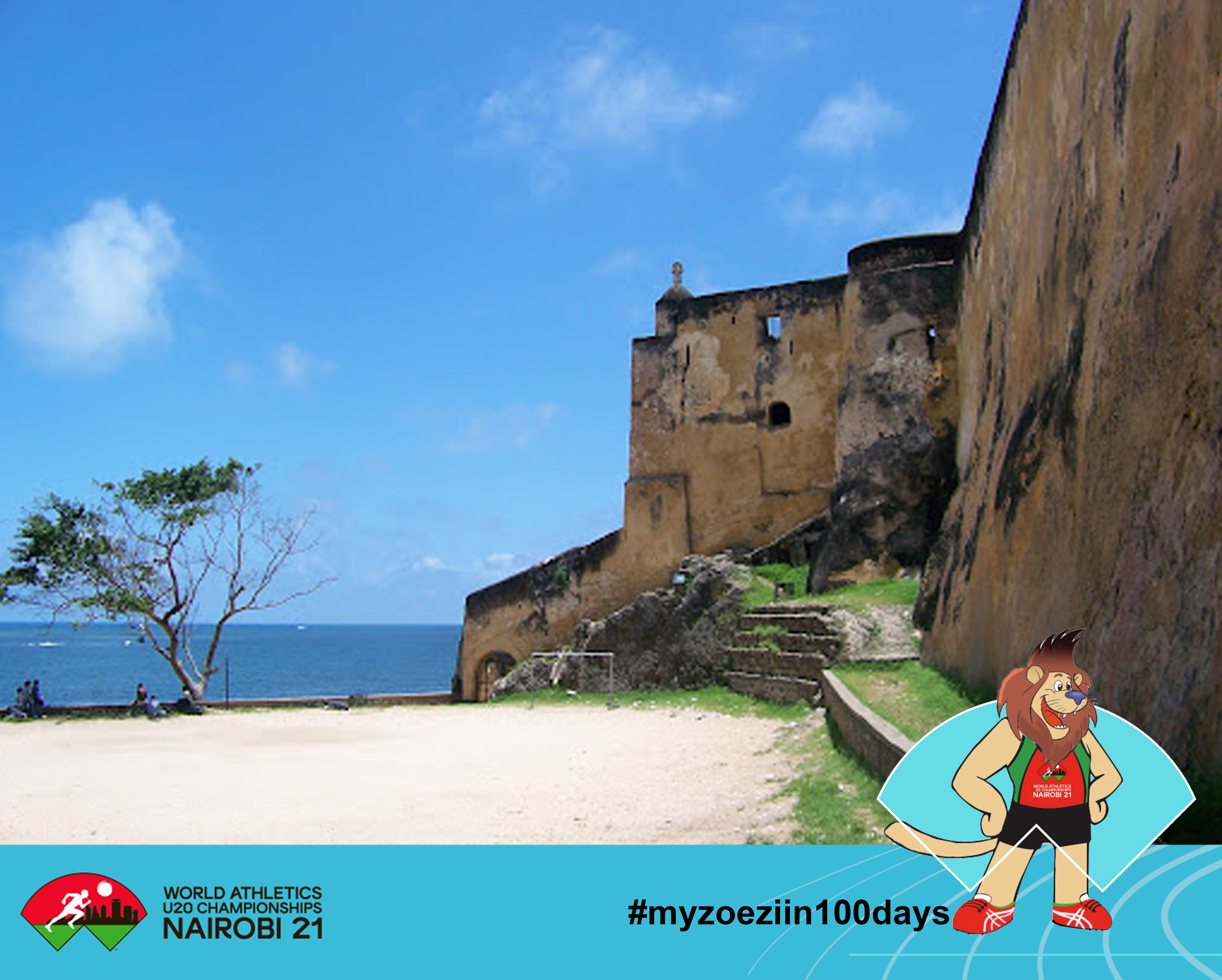
The Fort, which was built by the Portuguese in 1593-1596 to protect the port of Mombasa and was designed by Giovanni Battista Cairati, is one of the most outstanding and well-preserved examples of 16th-century Portuguese military fortifications and a landmark in the history of this type of construction.
The arrangement and structure of the Fort followed the Renaissance notion that the human body has perfect proportions and geometric harmony. The property is 2.36 hectares in size and comprises the fort's moat as well as its immediate surroundings.
Fort Jesus, Mombasa, was built by the Portuguese at the end of the 16th century on the southern edge of Mombasa, over a spur of coral rock, and remained under their control for a century. It is the first successful attempt by Western civilization to rule the Indian ocean trade routes, which had remained under Eastern influence until then.
The fort's architecture, with its dimensions, towering walls, and five bastions, represents Renaissance military architectural doctrine. Fort Jesus, Mombasa, provides physical evidence to the exchange of cultural values and influences between and among peoples of African, Arab, Turkish, Persian, and European origins through its construction and subsequent alterations.
The property's borders have been defined to encompass submerged archaeological relics in the sea in front of the fort, as well as the moat area next to Mombasa Old Town. Minor alterations to the Fort's interior bear witness to its history while posing no harm to its integrity. The land is in good condition, and there are no plans for development in the immediate area.
The Fort's buffer zone includes Mombasa Old Town, which is essential to the Fort's historic background. Property is adequately protected by the legal system: The Fort Jesus National Park in Mombasa was established in 1958, and the protected area contained the Fort and a 100-meter strip around it; presently, it is governed by the National Museums and Heritage Act of 2006. The buffer zone has now been designated as a Conservation Area.
However, there is still a disparity between the size of the declared Conservation Area and the size of the Buffer Zone. The property has an acceptable management plan in place, with the National Museums of Kenya serving as a significant stakeholder in its conservation and safeguarding.
Protection of the Fort from urban encroachment and inappropriate design in the areas adjacent to the Fort and in the surrounding Mombasa Old Town, which necessitates the reinforcement of dedicated management structures and staff, control of erosion of the rocks along the sea coast, and ongoing maintenance and conservation of the Fort itself are all long-term conservation and management issues.
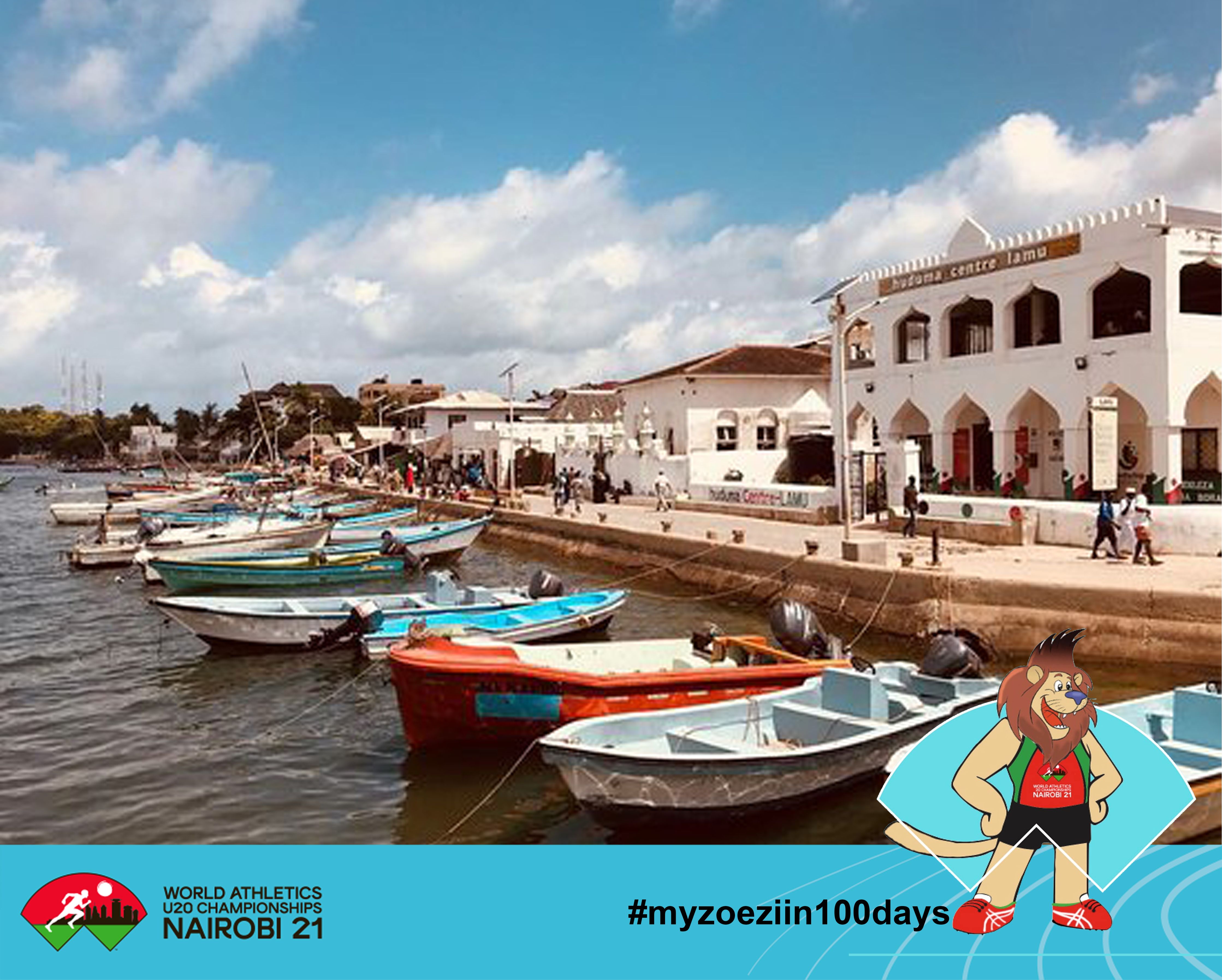
Lamu Old Town is East Africa's oldest and best-kept Swahili village, with its traditional roles retained. Built of coral stone and mangrove wood, the village is distinguished by its structural simplicity, which is enhanced by elements such as inner courtyards, verandas, and ornately carved wooden doors.
Since the 19th century, Lamu has hosted major Muslim religious festivals and has been a prominent center for the study of Islamic and Swahili civilizations.
Lamu has retained its social and cultural integrity, as well as its authentic building fabric, up to the present day, with a core consisting of a collection of buildings on 16 acres. Lamu, formerly the most important commercial center in East Africa, has had a significant religious, cultural, and technological influence throughout the region.
Lamu, a conservative and close-knit society, has maintained its importance as a major center for Islamic and Swahili culture instruction, as seen by the yearly Maulidi and cultural festivals.
Lamu, unlike other Swahili settlements along the East African coast that have been abandoned, has been continually inhabited for almost 700 years.
The development and collapse of East African seaports, as well as interactions between Bantu, Arabs, Persians, Indians, and Europeans, represent a key cultural and economic period in the region's history, which is best reflected in Lamu Old Town's architecture and town planning.
Narrow streets and majestic stone structures with amazing curved doors characterize the town, which is influenced by a unique blend of Swahili, Arabic, Persian, Indian, and European architecture styles. When entering the town from the sea, the buildings on the seashore, with their arcades and open verandas, create a coherent visual image of the town.
Internally, painted ceilings, big niches (madaka), small niches (zidaka), and pieces of Chinese porcelain adorn the vernacular structures. The structures are well-preserved and have a long history as examples of Swahili building technology based on coral, lime, and mangrove poles.
Lamu's architecture and urban layout graphically depict the cultural influences that have converged over 700 years from Europe, Arabia, and India, utilizing traditional Swahili skills to create a distinct culture. The property is distinguished by its distinctive Swahili architecture, which is marked by spatial order and twisting streets.
The origins of this labyrinth roadway arrangement can be traced back to Arab land distribution and urban construction practices. It is also characterised by clusters of homes separated into a number of small wards (mitaa), each of which is a collection of buildings inhabited by a number of closely linked lineages.