World Athletics Partner
World Athletics Partner
World Athletics Partner
World Athletics Media Partner
World Athletics Supplier
World Athletics Supplier
World Athletics Supplier


ROAD EVENTS - IMPACTS
WHAT'S HAPPENING?
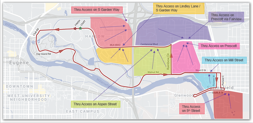
The men's marathon takes place on Sunday, July 17th from approximately 6am-9am and the women's marathon takes place on Monday, July 18th from approximately 6am-9am. Residents and businesses in certain Eugene and Springfield locations and commuters who frequent these areas may be impacted during event operational hours (12:01 a.m. to 10:00 a.m.) on both days.
WHAT DOES THIS MEAN?
The marathon route will be closed to vehicles during these times. For most people who live near the course, you will have alternate access as detailed below. For residents whose driveways or cul-de-sacs are directly on the marathon route, you will have no vehicular access in or out during the operational hours (12:01 a.m. to 10:00 a.m.). If you must use your vehicle during these times, plan ahead by moving your vehicle the night before to a nearby street not shown in red on the map below. Traffic delays should be expected for all residents and businesses during event operational hours.
Please note, from July 10-27, Martin Luther King Jr. Boulevard will be closed between both intersections of Leo Harris Parkway. Through traffic on Martin Luther King Jr. Boulevard will be detoured onto Leo Harris Parkway.
ALTERNATE ROUTES
The list below identifies specific Eugene and Springfield areas that will be impacted and provides alternate vehicle egress routes for each location.
EUGENE
• West of Interstate 5 in the Chevy Chase neighborhood: Use Lindley Lane / Garden Way to enter or exit the neighborhood. Police will have a controlled crossing across Martin Luther King Jr. Blvd. at Lindley Lane / Garden Way. Chevy Chase Street will be closed at MLK Blvd.
• Alton Baker Park: Alton Baker Park will be closed to all users. Day Island Road will be closed to bike and pedestrian use until 10am on both days.
SPRINGFIELD
• North of Centennial Blvd. & East of I-5: Use Fairview to travel East to Prescott Lane and Centennial Blvd. Westbound Centennial Blvd. is closed at Prescott Lane.
• South of Centennial Blvd. & West of Rainbow Drive: Police will have a controlled crossing at Aspen Street. Cross Centennial Blvd., Go North to Fairview Drive, East to Prescott Lane, Exit Prescott Lane and Centennial Blvd. eastbound to avoid the course closure. Westbound Centennial Blvd. is closed at Prescott Lane. West D Street is closed.
• Marilyn Ct. at Rainbow Drive: Residents on the cul-de-sac of Marilyn Ct. should park east of Rainbow Drive if they will need to get vehicles out on marathon mornings. Rainbow Drive will be closed.
• Raintree Way - West of Rainbow Drive: Residents in the cul-de-sac on Raintree Way west of Rainbow Drive should plan to park their cars to the east of Rainbow Drive if they need access during marathon mornings. Rainbow Drive will be closed.
• Jannette Ct.: Residents on the cul-de-sac Jannette Ct. should plan to park East of Rainbow Drive if they will need to leave during marathon mornings. Rainbow Drive will be closed.
• South of Centennial Blvd. between Rainbow Drive & Kelly Butte: Residents should take Prescott Lane north and go east on Centennial Blvd. Westbound Centennial Blvd. is closed at Prescott Lane. West D Street is closed.
• South of Centennial Blvd. & East of Kelly Butte: Go East or North to exit course area. Westbound Centennial Blvd. is closed at Prescott Lane. West D Street is closed.
• West D Street: Residents along West D Street, between Walnut Place and Pioneer Parkway East, should plan to park cars to the north and utilize either Aspen Street or Prescott Lane to exit the course area. Rainbow Drive will be closed. No driveway access will be possible during the event.
• Rainbow Drive: For residents whose driveway is on Rainbow Drive, plan to park your vehicle on Janus Street or Hamilton Street if you need access to your vehicle during event operational hours. Rainbow Drive will be closed. No driveway access will be possible during the event.
• Between Pioneer Parkway East & Pioneer Parkway West - South of West D Street: Residents should plan to park vehicles east of Pioneer Parkway East for faster egress on marathon mornings. Vehicles needing to move during the event must cross Pioneer Parkway East at controlled crossings.
• West of Pioneer Parkway West & South of D: Residents should go Northbound on Mill Street to cross West D Street to exit the course area. Pioneer Parkway East and West will be closed south of West D Street. Main Street will be closed.
• South of Downtown Springfield: Residents south of South A Street should take South B Street east to 5th Street North to exit the course area.
• Glenwood Area: Glenwood area residents should utilize detours on 17th Avenue and Glenwood Blvd. for access to the West and South. Eastbound Franklin Blvd. and the bridge into Downtown Springfield will be closed.
ALTERNATE BIKE ROUTES
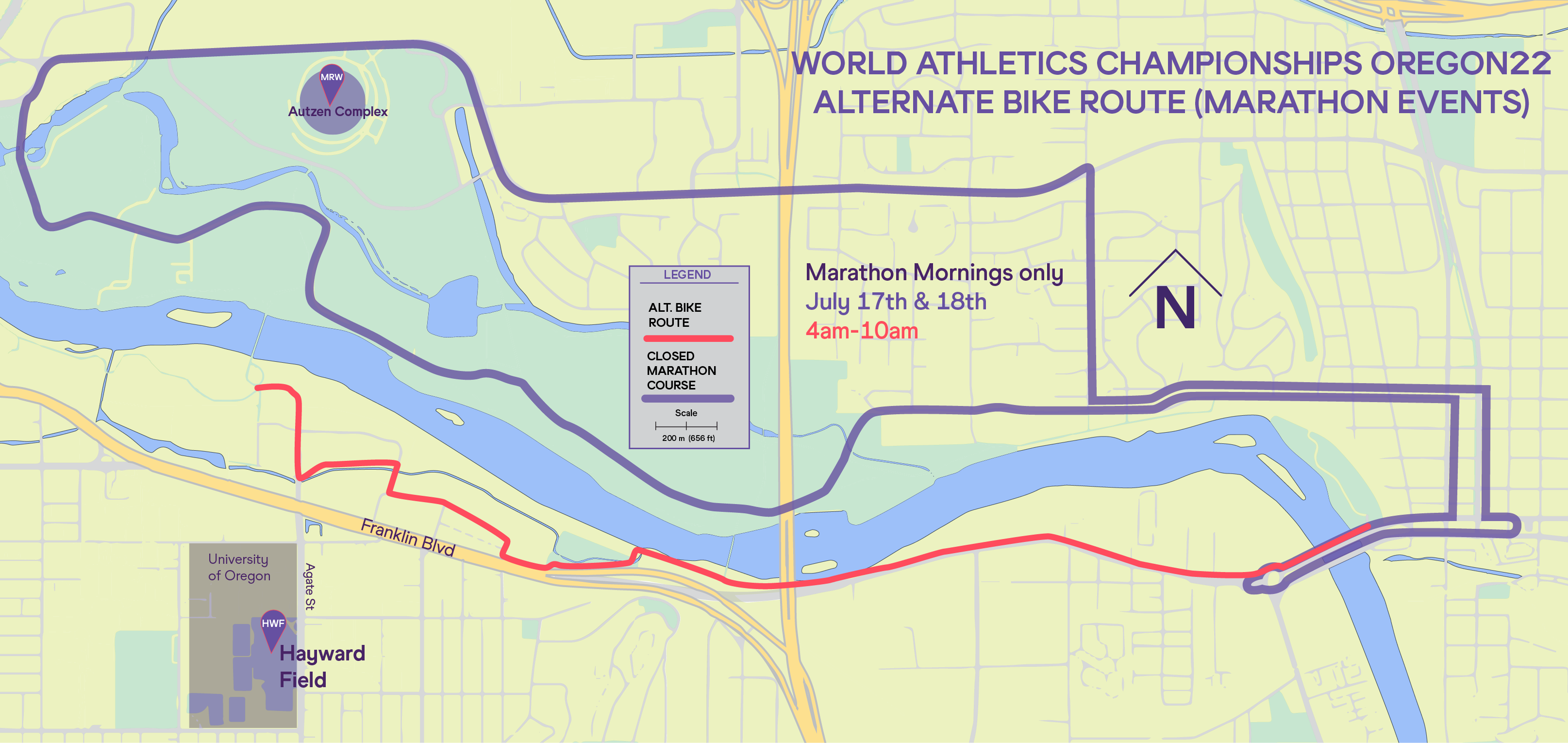
• Walk your bike across the Glenwood Bridge and take Franklin Blvd. West to the South Bank bike path
• Use Garden Avenue / Walnut Street to get to Millrace Drive
• Take Millrace Drive to Riverfront Parkway
• Pick up the bike path at the end of Riverfront Parkway and continue west from either side of the Frohnmayer Bridge
FOLLOW US


